Temperature Inversions - What Are They?
|
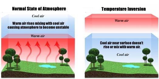
Normally, air in the troposphere (the lowest layer of the atmosphere) is warmer at lower altitudes and colder at higher altitudes. This causes a process called convection, in which the lower, warmer air rises while the higher, cooler air falls, mixing the air and preventing any pollutants from becoming too concentrated near the surface. However, several weather conditions can result in a "temperature inversion," where the air at higher altitudes in the troposphere is warmer than air at lower altitudes.
|
|
How Do Temperature Inversions Happen in the Bay Area?
|
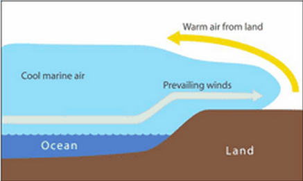
In the winter in the Bay Area, prevailing winds from the West push cold air from over the ocean towards the coast. As this air reaches the Bay Area, it pushes under the warmer air lying above the land, both cooling the coastal areas and creating a temperature inversion. This inversion results in a stagnant troposphere in the Bay Area, preventing pollutants from being dispersed throughout the atmosphere. Temperature inversions are also generally longer lasting during the winter because the sun is less intense, meaning that it cannot as easily warm the atmosphere and the Earth, which is the way inversions are usually dissipated during the summer. Without being heated by the Sun, an inversion has the potential to linger until a low-pressure weather system moves into the area, disrupting the local atmosphere and ending the inversion.
|
Do Temperature Inversions Happen in Other Places?
Yes - Temperature inversions happen all around the world, including in many areas in California besides the Bay Area. Inversions can occur over Los Angeles and in the Central Valley. In the Valley, where altitude is low and air pressure is high, air tends to cool near the ground during the night, creating a temperature inversion and a stagnant atmosphere vulnerable to pollutants.
